 This trip we decided to do something we had never done before- a helicopter tour!
Kauai’s 552 square miles is only about 10% accessible by car, making it a perfect locale to see from the sky. We chose Island Helicopters, which caught my eye with its Jurassic Park heavy branding and but also with its modified helicopter doors, which include more window for sightseeing and photography. Other companies offer helicopter tours sans doors for true photography buffs, but this sounded mildly terrifying for first time passengers.
 We chose the 50 minute Grand Circle Tour, a popular offering across helicopter companies. The flight left out of the Lihue Airport, conveniently just down the road from the Kauai Beach Resort where we were staying. Each pilot can fly up to nine tours a day so there are often multiple time-of-day options even for last minute bookings (we only booked one day in advance). Our cruise would take us and four other passengers around the island in a circle that started on the east shore and took a clock-wise route around the highlights of Kauai.
 Part of the reason we chose to to helicopter was the desire to see what Waimea Canyon was all about. This west shore standout, “the Grand Canyon of the Pacific,” has hiking trails and scenic overlooks if you prefer to drive there, however, the full expanse was breathtaking from above. Checking it out this manner also saved us what would have easily been a half to full day excursion by car.
 Our helicopter was much more nimble than I would have expected and our pilot maneuvered in and out of the valleys and over ridges with ease as he followed mountain goats and pulled us over waterfalls, all while keeping up a nice banter over the intercom. Our pilot, a former Vietnam pilot and school teacher originally from Kauai, helped us relax by “reading the air” to tell us when drops would occur. His knowledge helped us feel confident we would not be needing the inflatable life jackets we were required to strap around our waists prior to boarding.
  The pilot’s commentary is set to a background of everything from the Hawaiian folk music that is ever-present on the island to reggae to the Jurassic Park theme song pipped in through your headphones. You can also ask questions through a little radio.
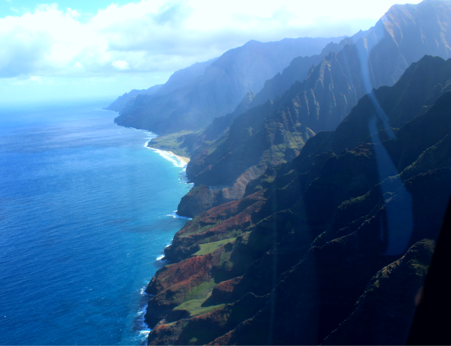 The Na pali coast of the north shore is gorgeous and fairly inaccessible except for by air or by sea. Na pali, which means “the cliffs” or “many cliffs” in Hawaiian, consists of 17 miles of sheer drop-off cliffside with valleys between that were inhabited first by Polynesian navigators around 1200 AD.
 After soaring over the ocean to take in the full expanse and cruising over Hanalei Bay, we flew up towards Honopu Beach (sandy stretch, top left of photo). The beach and interior valley were film location for Six Days Seven Nights, King Kong, Pirates of the Caribbean and The Man with the Golden Gun, among other movies.
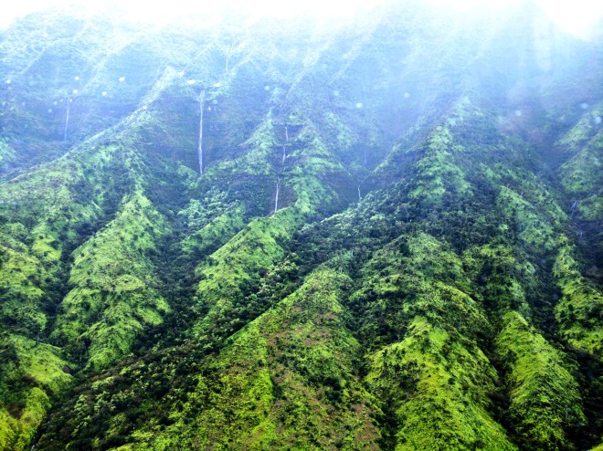 We choppered inland through Honopu Valley, also known as “the Valley of the Lost Tribe.” The lush basin had literally hundreds of waterfalls pouring down the sides. According to our pilot, the tribe of people who lived here until the 19th century disappeared (thus the name) and he also told us of the rumor of early inhabitants with red hair and light colored eyes in the area. This misty vale is the site of many Hawaiian myths and legends, some of which have now been lost as the oral history of the Hawaiian people gets passed down less and less frequently through generations.
 The background of this photo contains Mount Waiʻaleʻale, barely visible through the cap of fog, who’s name means “rippling water” or “overflowing water.” Shrouded in mist and often billed as the wettest place on earth, (regions of Meghalaya, India are actually wetter), this shield volcano still gets an impressive 335 days of rain per year. Our pilot was able to take us up close to the many thin waterfalls cascading down sheer rock face and reported that locals are happy when the moisture sits inland there and understandably less so when the rain moves outward to the shores.
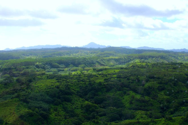 We ended our trip heading southeast over the jungleous stretches of the eastern interior. We flew over the Halelea Forest Reserve, Kealia Forest Reserve and the Wailua River before reaching coastline again. Our pilot was stoked to tell us about the new bike trails and connections around Lydgate Beach Park, where a multi-use path runs along the shore and is now being expanded.
Though we were nervous about our flying adventure, it was a great way to drink in the scenery and experience the whole of the island. Not as out of reach as we had imagined price-wise, it is a highly recommended activity to partake in on your Kauai vacation!
Pro tips:
Booking online was great for deal comparison, but check with your hotel (if you have one) to see if they can get you any specials. If you plan to do any other guided activities, check with providers for reciprocal deals and discounts.
Though they do distribute passengers through the aircraft by weight, it would be worth checking with whomever you talk to at a company about where you’ll be placed on the aircraft and perhaps booking early for best placement. Next to the pilot was prime visibility, with directly behind them as your second-best option and the passenger-side back was still good but with the least visibility.
